- Temperature average 0° to 3° below normal
- Precipitation average near normal or below normal
- More pronounced than past two winters, not as harsh as three years ago
- A few notable winter storms and severe Arctic outbreaks likely, given the pattern being forecast
 |
| Forecast made by Meteorologist Kevin Lawrence |
 |
| Forecast made by Meteorologist Kevin Lawrence |
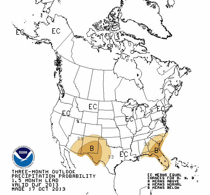
Climate Prediction Center forecast for December-January-February issued October 17:
 |
| Forecast by: Climate Prediction Center |
 |
| Forecast by: Climate Prediction Center |
"EC" stands for Equal Chances. That implies there is not a strong enough signal to determine an Above Normal, nor Below Normal threshold.
Note: NOAA will issue their winter forecast in late November, approximately one month later than normal due to the government shutdown.
More In-depth analysis:
The past two winters have been somewhat tame in western North Dakota. Keep in mind I am only referring to the "meteorological winter" months of December, January and February. This past winter, Bismarck's two largest snowstorms occurred in November and April, with a combined snow total of 32.3 inches. For December, January and February, a combined 18.1 inches of snow was recorded. More In-depth analysis:
Temperatures for the three winter months last year averaged 1.5° above normal. Therefore, when looking at the winter months as a whole, it was not particularly severe.
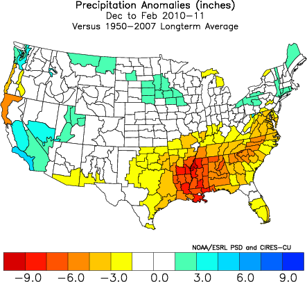
Here is a look at last winter in the continental United States. Yellow/orange is above the long-term average, non-colored regions are average, and green/blue shades are below.
 |
 |
Let's go back one more year, to the winter of 2011-2012. You'll definitely notice it was even milder!
 |
 |
Do you remember the winter season three years ago?!?! That was our last "real" winter:
 |
 |
When I wrote my winter forecast in October 2010, I coined it my "Slam Dunk" winter because several of the atmospheric/oceanic indices I incorporated into making my forecast agreed to a high likelihood of a certain outcome. We had the continuation of the negative phase of the Pacific Decadel Oscillation (PDO), A moderate La Niña episode of the El Niño Southern Oscillation (ENSO), a negative phase of the North Atlantic Oscillation (NAO), and a predominately negative phase of the Arctic Oscillation (AO).
When you have a significant amount of agreement, odds favor a certain outcome. Three years ago, I was forecasting a harsh winter with above normal amounts of snow. Below, I define what each of the indices mentioned above means.
What about December 2013 through February 2014? Is it another "Slam Dunk" case? Not quite. We don't have all the signals pointing in the same direction. We appear to have neither an El Niño, nor La Niña as the ENSO phase is forecast to remain neutral through spring 2014. The PDO, however will likely average negative overall for perhaps years to come. The NAO is forecast to generally be negative, and the AO is too difficult to determine. November could turn out to be a stormy month with numerous storm systems coming ashore in Canada and the U.S. If Canada forms a good snow foundation during the month, that could significantly affect temperatures in North Dakota during the course of the winter season. The more snow, the less air mass modification, hence colder.
Let's take each one of the teleconnections above and break it down to what they mean.
First, let's talk about one of my favorites, the Pacific Decadal Oscillation (PDO):
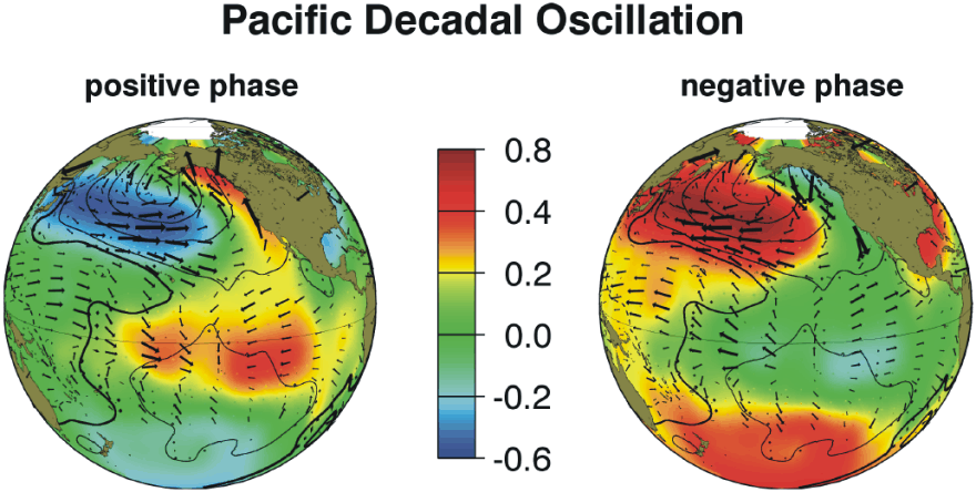
"The Pacific Decadal Oscillation, or PDO, is often described as a long-lived El Niño-like pattern of Pacific climate variability (Zhang et al. 1997). As seen with the better-known El Niño/Southern Oscillation (ENSO), extremes in the PDO pattern are marked by widespread variations in Pacific Basin and North American climate. In parallel with the ENSO phenomenon, the extreme phases of the PDO have been classified as being either warm or cool, as defined by ocean temperature anomalies in the northeast and tropical Pacific Ocean." Credit: Nathan Mantua, Ph. D
Over the past several years, the PDO has trended negative. This more often than not implies a colder winter season for the Northern Plains. Interestingly, the PDO was predominately positive in the 1990s. Several winters of the '90s were mild. With the phase switch about five years ago, our winters have become a bit more pronounced, just as the 1980s. Notice the temperature pattern in the Gulf of Alaska. During the positive phase, sea surface temperatures are warmer. The opposite is true during the negative phase. The differences between phases is even more striking farther west, and near the equator.
El Niño Southern Oscillation (ENSO):

"Sea surface temperature in the equatorial Pacific Ocean (above). El Niño is characterized by unusually warm temperatures and La Niña by unusually cool temperatures in the equatorial Pacific." Credit: NOAA
The forecast through the winter of 2014 calls for a neutral phase, meaning no El Niño or La Niña signal.
The North Atlantic Oscillation (NAO):

"The North Atlantic Oscillation (NAO) index is based on the surface sea-level pressure difference between the Subtropical (Azores) High and the Subpolar Low. The positive phase of the NAO reflects below-normal heights and pressure across the high latitudes of the North Atlantic and above-normal heights and pressure over the central North Atlantic, the eastern United States and western Europe. The negative phase reflects an opposite pattern of height and pressure anomalies over these regions. Both phases of the NAO are associated with basin-wide changes in the intensity and location of the North Atlantic jet stream and storm track, and in large-scale modulations of the normal patterns of zonal and meridional heat and moisture transport, which in turn results in changes in temperature and precipitation patterns often extending from eastern North America to western and central Europe." Credit: National Climatic Data Center
Generally, a negative phase of the NAO brings more Arctic air into the Northern Plains, opposed to a positive NAO state, which often brings Pacific (milder) air.
The Arctic Oscillation (AO):

There are MANY other factors to consider and analyze not covered here, such as the Madden-Julian Oscillation (MJO), the Pacific North America (PNA), etc. The list goes on and on. I have used what has worked well in the past. No forecast is a "Slam Dunk", even though it turns out that way sometimes. For instance, two winters ago, we had the continuing negative PDO phase and a moderate La Niña event. That would suggest a colder pattern for the Northern Plains. That didn't happen. Other indices, such as the AO and NAO had counteractive phases.
I look at long-term weather patterns as a hobby. Remember, I've always said in making these forecasts that day-to-day weather in the long-term is impossible to predict not much more than a week out. What can be done, however, is forecast a trend, that often produces a certain type of weather. That is what I am trying to accomplish here. Also, I want my forecasts to be straight-forward with minimal amounts of technical jargon that's hard to understand.
I look at long-term weather patterns as a hobby. Remember, I've always said in making these forecasts that day-to-day weather in the long-term is impossible to predict not much more than a week out. What can be done, however, is forecast a trend, that often produces a certain type of weather. That is what I am trying to accomplish here. Also, I want my forecasts to be straight-forward with minimal amounts of technical jargon that's hard to understand.
If you try to Google "winter forecast", you will get back all kinds of information from meteorologists and weather enthusiasts, to novices with no experience. Be careful. Don't believe everything you see. The Internet is a wonderful place to research all sorts of data, but finding credible information and sources can be difficult.
When I wrote "Kevin's Corner" long-range forecasts in the past, I never had the ability to have readers leave comments. That was a major downside. That has now changed with this new blog. Please consider leaving questions are comments below.
Other ways to reach me:
When I wrote "Kevin's Corner" long-range forecasts in the past, I never had the ability to have readers leave comments. That was a major downside. That has now changed with this new blog. Please consider leaving questions are comments below.
Other ways to reach me:
- lawrence@kfyrtv.com
- Facebook: Click here.
- Twitter: @KevinsCorner
Thanks for taking the time to do this. I look forward to reading it every year.
ReplyDeleteGlad you enjoy it. I wasn't going to make one this year, but I received a lot of requests.
DeleteThank you Kevin for posting your winter trend forecast. I have been a faithful reader of your "Kevin's Corner" for years and have found it to be pretty close! Please continue it!
ReplyDeleteThank you for your input. Nothing is a sure bet, but I do find forecasting long-term trends a hobby.
DeleteI look forward to your winter forecast every year. It is amazing how accurate all of your forecasts are! I also watch and even DVR all of your weather segments. Job well done!
ReplyDeleteThank you very much Don. A renowned long-range weather forecaster by the name of Joe Bastardi is calling for pretty much the same winter forecast. I often analyze his forecasts before I put mine together, but this year I didn't. I had no idea what he was calling for until this morning. He has our winter temperatures about 2-4° below normal just like I do. We shall see! Thanks again for reading and watching on TV.
DeleteI always look forward reading "Kevin's Corner". Sometimes I love what you write and others....not so much. LOL Keep up the good work and I'll keep my fingers crossed for a warmer winter than you predict. I also really enjoy watching your weather segments on tv. :)
ReplyDeleteI think you're the best weather man on the planet because all I do is expect the exact opposite of what you forcast and it almost always happens.
ReplyDeleteIt's forecast, not forcast. ...And I'm a meteorologist, not a weatherman. To that, please provide examples to substantiate your claim. Thanks for your comments though. That is what this is for.
DeleteKevin you might get a kick out of this... Fool me one shame on you, fool me twice shame on me, fool me 94,245 times....you must be a weatherman...I mean meteorologist!!!
DeleteThanks. Have a good one. I'll leave it at that.
DeleteSo... How's that "exact opposite" turning out for you?! Looks like my forecast is right on, so far. :) Must be why you haven't commented as of late. (lol)
DeleteI finally found your long term winter forecast, I've been looking everywhere. Your forecasts always seem to be right on, just like the winters we had beginning in 2008, I seem to remember others' forecasts who were just completely off, but yours proved pretty close. Anyway, do you think the trend will include a lot of long cold spells like the one we are in now, or more occasional?
ReplyDeleteJay, thanks for your comments. We're early in, but so far winter is doing pretty much the trend I forecast when I released this in late October. I think more cold air keeps December very cold, although some brief warm-ups. I am starting to wonder if January might be less severe. Could this be a "bookends" winter, where it starts rough, ends rough and calmer in the middle? That's a possibility, but I'm not confident enough to forecast that yet.
DeleteKevin, thanks. I really do hope it turns out to be a "bookends" winter. I grew up here but this cold is wearing on even me. I will check back for updates.
DeleteThank you! Make sure to keep an eye on my facebook page, which is where I post almost daily: https://www.facebook.com/pages/Kevin-Lawrence-KFYRTVcom/142135109172970
DeleteThanks kevin's Corner ..... It's amazing research.
ReplyDeleteI am very much appreciate your valuable research about next weather situation.